La Nina Conditions Hold Ground-IOD Tumbles

Key Takeaways
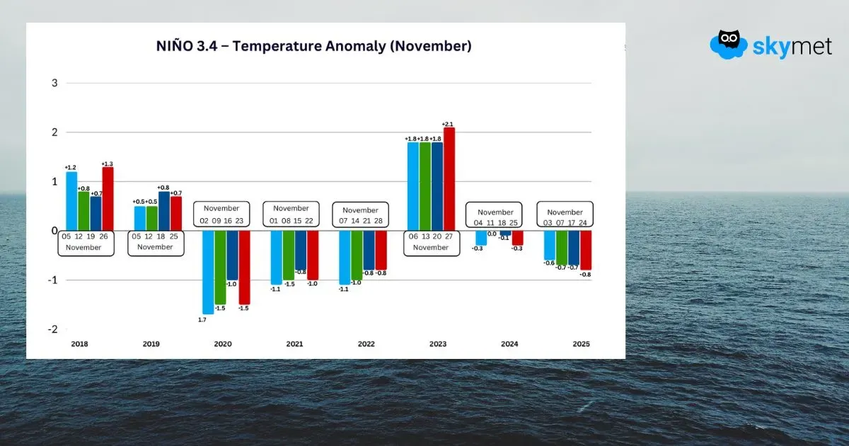
- November SST anomalies historically show a clear flip in sign between El Niño and La Niña years, illustrating strong ENSO phase transitions.
- La Niña 2025–26 is likely to develop further, supported by negative SST anomalies and atmospheric indicators.
- A weakening negative IOD is on track to move toward neutral conditions by December 2025.
- MJO is losing amplitude and will exert minimal influence on convection over the Indian seas in the immediate term.
Sea surface temperature (SST) variability in the tropics can significantly impact the global climate through atmospheric circulation. Water covers more than 70% of our planet’s surface. SST anomalies give scientists a way to monitor the evolution of ENSO phases. Such data provide leads to predict potential impacts in the Pacific region and, through teleconnections, in other parts of the world weeks in advance. It is a delight to watch how the temperature anomalies behave and follow a stipulated pattern during the evolving phase of La Niña/El Niño.
Year 2018 was an evolving El Niño year, and the El Niño conditions were carried forward through the whole of 2019, with a brief collapse halfway through the monsoon season. The intention here is to keep the focus on the month of November and speculate on conditions for the succeeding months. The SST stuck to positive anomalies in Nov 2018 and 2019, both. Then came the triple-dip La Niña in 2020–21–22. These anomalies turned negative in each of these years, invariably breaching the mark of –1°C. The triplet of La Niña was followed by El Niño in 2023, and sure enough, the Niño indices switched over to the positive side.
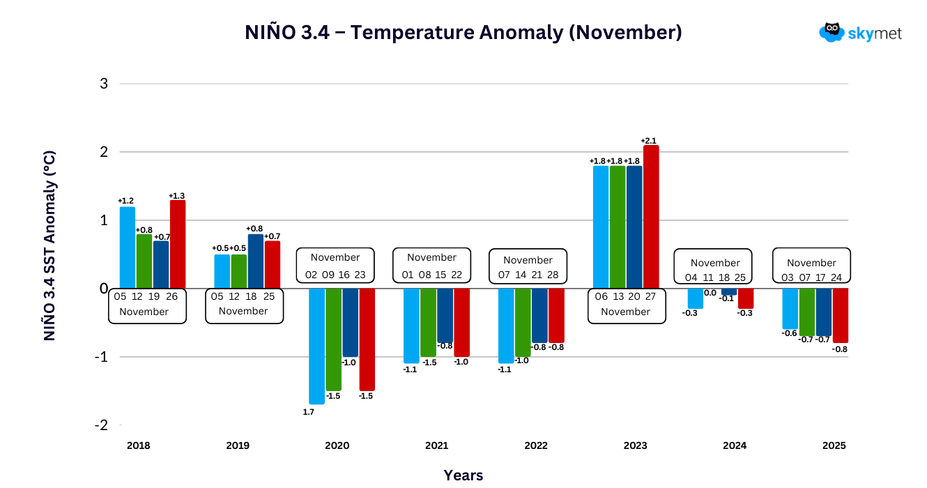
La Niña appeared briefly in winter 2024, and a similar track is getting retraced this year as well. The month of November was dominated by cooler sea surface temperatures, with the threshold being ruptured repeatedly. It is surely captivating to observe how diligently the standards and patterns are followed during ENSO events.
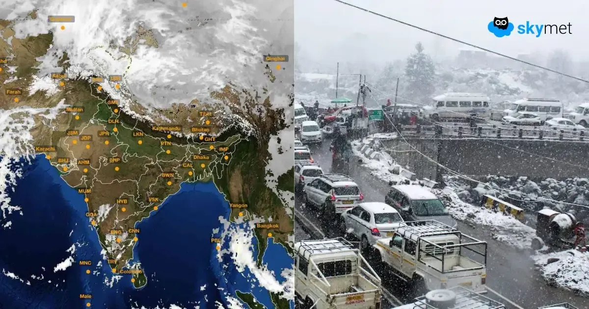
ENSO: La Niña has the capacity to alter both the direction and velocity of the trade winds, which trigger the winter season in India. La Niña typically brings colder, more severe winters to North India by strengthening westerly winds that pull in frigid air masses from Central Asia. During La Niña, the core of the westerly jet stream gets pushed northward. Strength and intensity of La Niña matter when gauging the scale of weather activity. La Niña this season is expected to be short and brief. The intensity may also remain mild, or at best moderate, somewhat similar to last year. Notwithstanding the role of La Niña in the ferocity of winters, the interplay of western disturbances with the topography of the Western Himalayas determines the spatial and vertical distribution of precipitation.
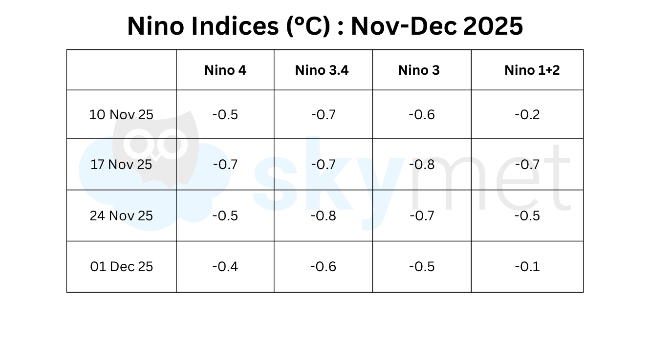
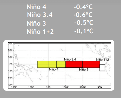
There were large fluctuations observed in the temperature anomalies across all the Niño indices. Niño 3.4, the marker for ONI, got warmer by a few notches. The largest variation, as expected, was seen next to the coastline of Peru. Notwithstanding, the threshold for La Niña remains intact, and the event is likely to evolve with favourable markers in Dec 2025.
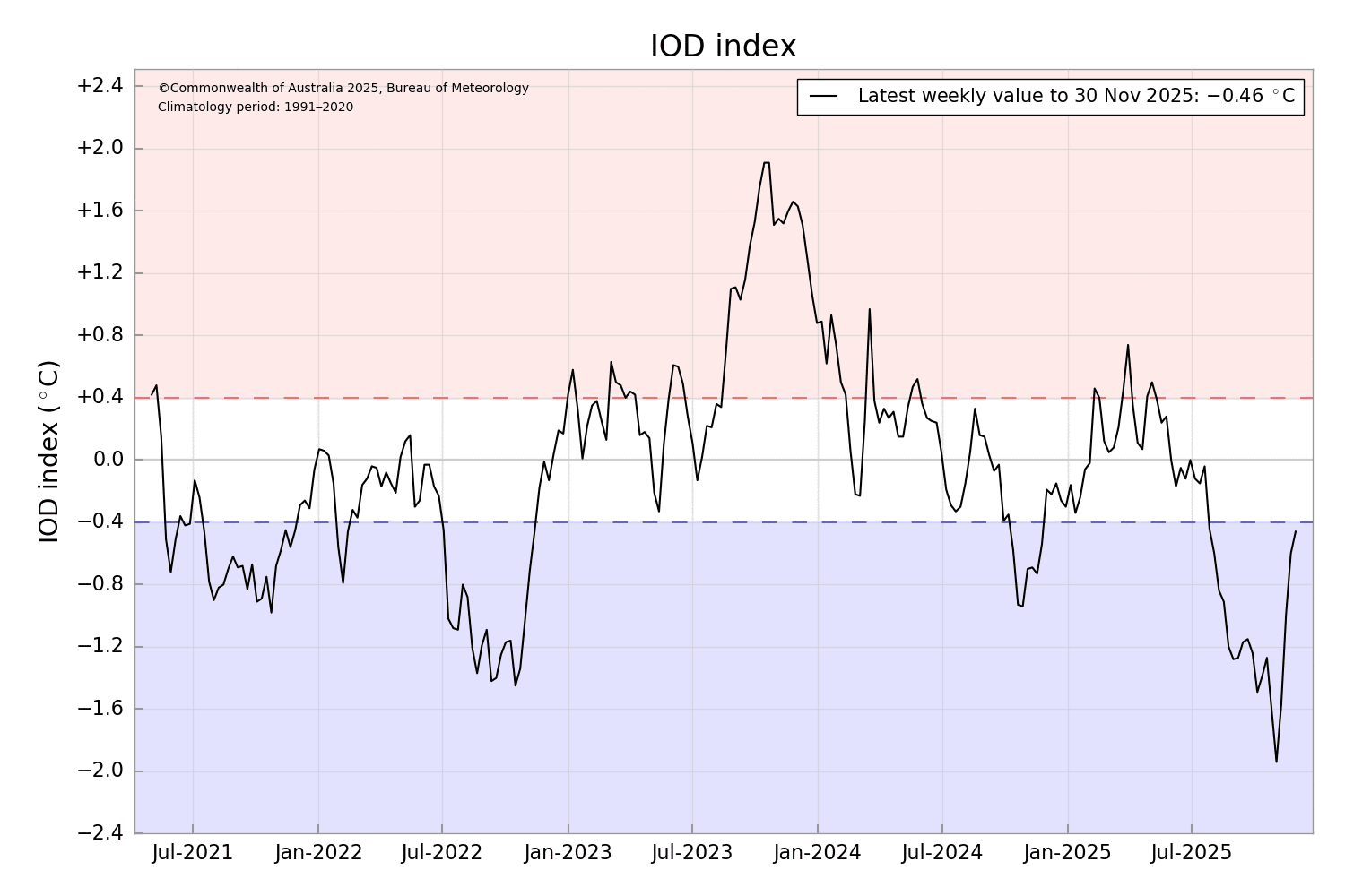
IOD: The negative Indian Ocean Dipole event remains active but has been weakening steadily over the last four weeks. The latest index value is –0.46°C for the week ending 30 Nov 2025. It has considerably dropped from the highest value of –1.94°C on 03 Nov 2025 to now reach close to the threshold mark of –0.4°C. The Bureau’s model predicts a return to a neutral IOD in Dec 2025. This is consistent with most international models assessed and typical of the IOD cycle.
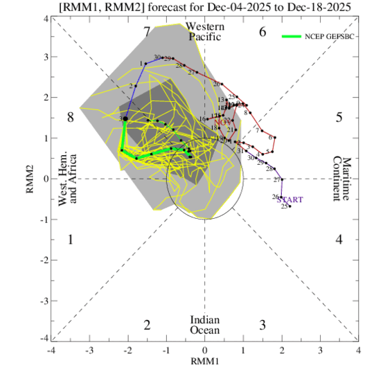
MJO: The Madden–Julian Oscillation is propagating eastward from the Western Pacific to the Western Hemisphere and Africa in Phase 8. The amplitude is shrinking, and the signal may crash into the RMM unit circle by the start of next week. Thereafter, it is likely to meander within the circle with least consequences. Some models do show potential for the MJO signal to reorganise and propagate into the Indian Ocean after mid-December. As of now, the MJO is not going to support any convective activity over the Indian seas.
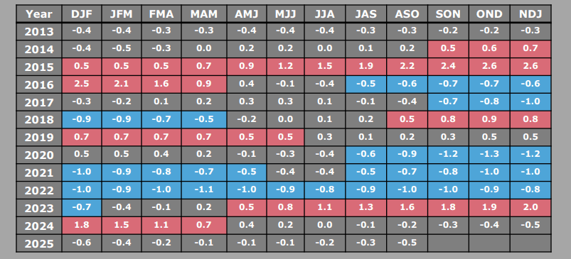
In this article, the focus was on studying and comparing the Pacific Niño Index (Niño 3.4) in the month of November during La Niña and El Niño years. The deliberations revealed a clear manifestation of reversal of temperature anomalies from one to the other. The month of December starts with La Niña conditions aligned with seasonal patterns. The temperature anomalies are expected to trigger the Oct–Nov–Dec quarter to breach the threshold mark of –0.5°C, like the previous one. This will strengthen the foothold of La Niña 2025–26.