


Statistically, 10th September marks the peak in the Atlantic Hurricane Season. On average, eight named storms form, including three hurricanes and one major hurricane. It has defied the ‘pre-season’ forecast of an above-average season for storms. So far in 2025, there have been six named storms, one of which became major hurricane ‘Erin’ in mid-August. With no activity expected in the next one week or so, this will have been only the second year since 1950 where there are no named storms from the end of August to mid-September. It is almost a repeat of last year when it had been unusually quiet with no activity between 21 Aug and 09 Sep, the most prolonged lull in the hurricane record for around 50 years. Otherwise, the 2024 hurricane season was notably active, featuring 18 named storms, including 11 hurricanes and 05 major hurricanes.
June is when the six-month-long season begins, but the climax of hurricane activity occurs from mid-August through September and into the first half of October. Right in the middle is September 10, the statistical high point of the season. Based on historical data, there is a probability of storms in excess of 75% over the Atlantic basin around this peak. Anyway, this has been defied this year and the Atlantic is pitching a shutout on its official peak, a feat that last happened in 2016.
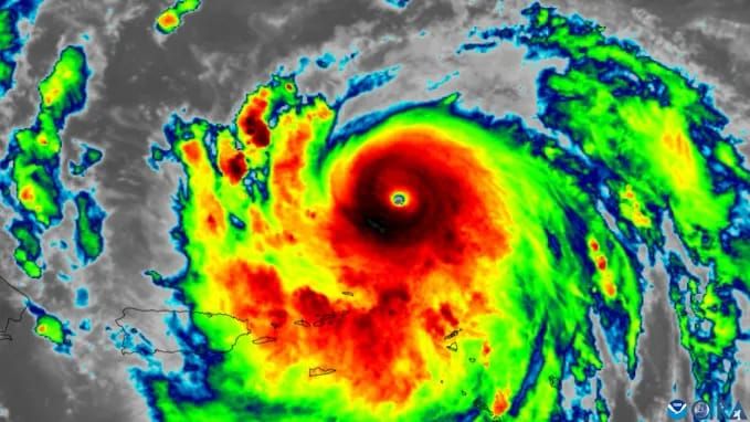
Right now, much of the Atlantic basin has plenty of warmer-than-average water for prospective storms to develop. These temperatures are not as high as the record levels set in 2023 & 2024, but they are still warmer and have the heat potential to churn a storm. Courtesy of these temperatures, storm Erin became the fastest-strengthening Atlantic hurricane on record when it hit the highest Category 5 status in mid-August.
In a special report from Colorado State University (CSU) addressing the quiet spell, there are three main factors explaining why the season has been subdued.
- The first is that the tropical Atlantic has become ‘dry and stable’. This means there is not enough moisture, and atmospheric instability does not suffice for the development of severe thunderstorms capable of initiating tropical storms.
- Wind shear – changes in wind speed and direction at different levels of the atmosphere. Excess wind shear can suppress the development of storms in the formative stage itself. It can rip apart fully developed hurricanes and tropical storms.
- And lastly, there has not been a supply of increased thunderstorm activity in West Africa, which would normally travel west into the Atlantic where they can be the starting mechanism for developing tropical cyclones.
Looking ahead, just over 50% of the entire hurricane season’s activity occurs after the September 10 peak. The bottom line is there’s still a long way to go before the season ends. It is important to stay prepared, especially for those living in hurricane-prone areas.


