


ENSO variability is the biggest cause of year-to-year differences in weather conditions across many regions. In La Niña years, the east-to-west Pacific trade winds are stronger, pushing warm surface water to the west and drawing up deeper and cooler water in the east.
El Niño events happen when the trade winds wane, allowing the warm waters to spread back eastward, smothering the cooler waters and leading to a rise in global temperatures. El Niño generally peaks during Northern Hemisphere winters, and its heating effect takes months to get absorbed, as the water has an extended memory. It means that the years following an El Niño event are much more likely to set new global temperature records. Year 2023 was a strong El Niño year, and yes, 2024 has been widely reported as the hottest year on record globally, surpassing previous records set in 2023 and other recent years. Multiple scientific organizations, including NASA, WMO, and the EU’s COPERNICUS Climate Change Service have confirmed this finding based on their respective data analyses. Going by this logic, 2024 being a La Niña year, year 2025 may be slightly cooler overall, though still one of the warmest years on record. Reports indicate that the first four months of 2025 were the warmest on record, but a potential shift to cooler ocean temperatures could lead to a slight decrease in global temperatures later in the year. Under climate change, the impact of ENSO events is going to get stronger, and the two put together are likely to trigger extreme heat conditions in some parts of the globe, more so during El Niño events. Mind you, the correlation between extreme weather and global mean temperature is not very strong.
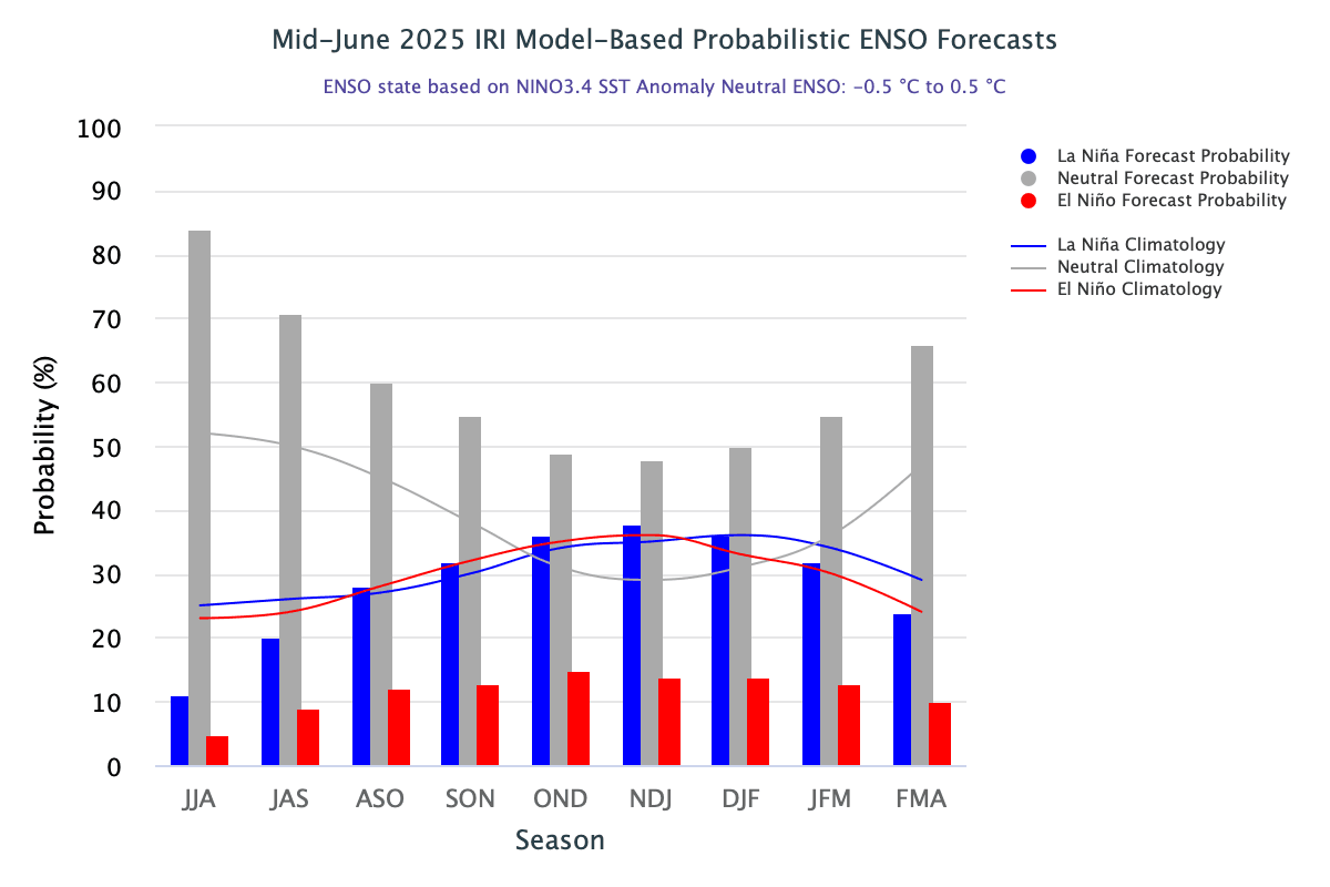
ENSO: During the last four weeks, near to below-average SSTs continued in the far east-central Pacific, while above-average SSTs persisted in the far eastern Pacific. As per the model forecast, the El Niño component share remains under 15%, and the La Niña contribution does not exceed 30%, and that too at the end of the monsoon season. So, the surface temperature component of ENSO will be largely governed by the ENSO-neutral conditions during the southwest monsoon season. The Southern Oscillation is the atmospheric component of ENSO. This component is an oscillation in surface air pressure difference between Tahiti (in the Pacific) and Darwin, Australia (on the Indian Ocean). As of June 2025, the traditional and equatorial SOI continue to remain in the ENSO-neutral range.
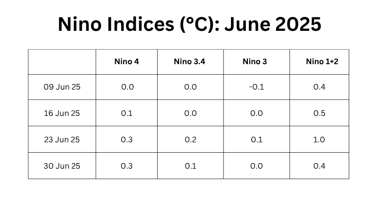
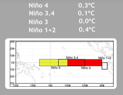
The central equatorial Pacific has constantly remained cooler than the flanks on either side. Nino 3.4, the marker for ONI, and Nino 3 sharing a boundary with Nino 3.4, have rarely gone above 0°C. The average of Nino 3.4 for the last six weeks is zero-zero, and for Nino 3, it is -0.1°C. Nino 1+2 has remained the warmest, with an average of +0.6°C during this period. Apparently, these fluctuations are attributable to the proximity of the coastline and turbulent flow of water. Nino 3.4 is likely to stay between +/- 0.1°C for the next about four weeks.
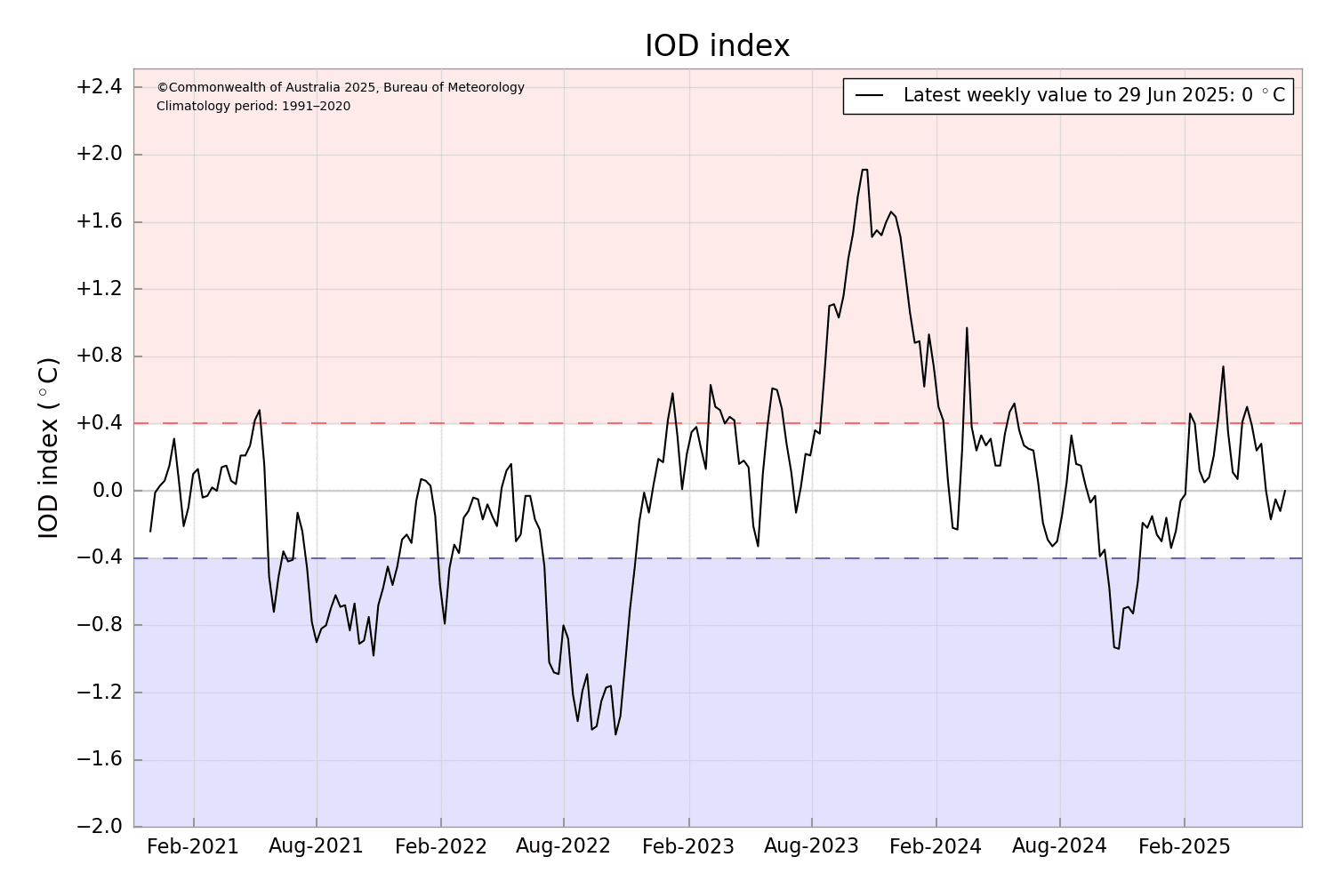
IOD: The Indian Ocean Dipole has largely remained within the neutral bounds of +/- 0.4°C during monsoon 2024. A similar trend is likely during the current monsoon season. The occurrence of consecutive positive IOD events is extremely rare, and the presence of negative IOD in successive years is also not very common. For an IOD event, the index value needs to be sustained for eight weeks in a row. While positive IOD can weaken the impact of El Niño, a negative IOD with El Niño has the potential to ruin the monsoon rainfall. The Indian Ocean Dipole is neutral. The latest value of the IOD index for the week ending 29th June was 0.0°C. The index has remained in the neutral bounds for seven consecutive weeks. Another couple of weeks, the event can be rated as Neutral IOD.
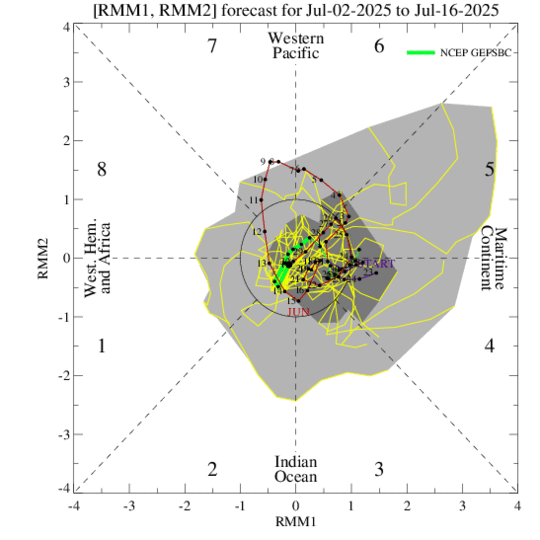
MJO: The Madden-Julian Oscillation continues to be disorganized. The MJO signal is likely to meander over Phase 1 & 8 with a weak amplitude during the first ten days of July 2025. Any meaningful MJO signal is unlikely during the subsequent week, as well. Regardless of any renewed MJO activity, the overall environment will become much less favourable for tropical cyclogenesis in the Western Hemisphere during the next several weeks.
Southwest monsoon kept a speeding pace on resuming the activity after a long pause. The low-pressure areas or the cyclonic circulations originating over the Bay of Bengal and moving across the central parts have been a constant feature. Each of these systems left a trail of embedded circulation at the rear end, triggering another weather system. There are early indications that this sequence may take a break after 10th July, wherein the eastern end of the monsoon trough may shift northward along the foothills. If so, there could be a temporary pause in the vigorous monsoon activity over a major portion of the country.


