


The Indian Ocean Dipole (IOD) is in the early stages of a negative IOD phase. With signs of strong coupling between the ocean and atmosphere, a negative IOD event is becoming increasingly likely. The event may commence even during the withdrawal phase of the southwest monsoon over the Indian subcontinent. The IOD is a climate driver that involves the movement and location of warmer and colder waters along the equator in the Indian Ocean.
These ocean movements have a large impact on climate variability and weather patterns for the countries geographically located on either side of the equator in the tropical latitudes. A negative IOD is a climate phenomenon where the waters on the eastern side of the Indian Ocean become warmer than average, while the western side, near Africa, becomes cooler. This temperature difference impacts atmospheric circulation, leading to characteristics like increased rainfall in parts of Australia and Indonesia and a higher risk of drought in East Africa. A negative IOD event commencing before or during the onset phase of monsoon tends to suppress the Indian Summer Monsoon rainfall, with more “break days” when there is little or no rainfall.
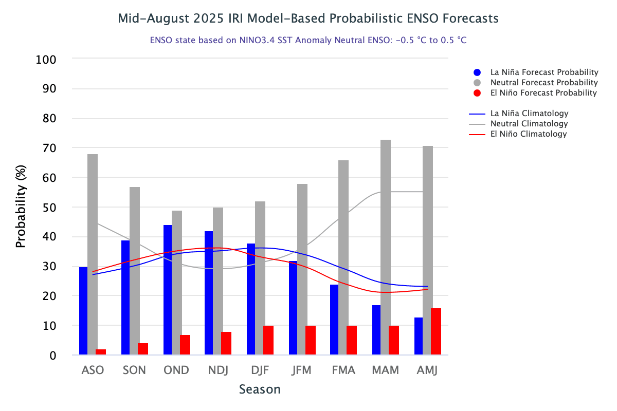
ENSO: According to the World Meteorological Organization (WMO), the probability of La Niña returning between now and December is between 55%-60%. The IRI model-based ENSO forecast indicates the return of La Niña in the quarter Oct-Nov-Dec. The SST in the equatorial Pacific has already begun to cool, and the data shared by WMO indicates the equatorial Pacific will cool to La Niña levels from Sep to Dec 2025.
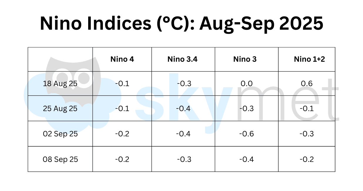
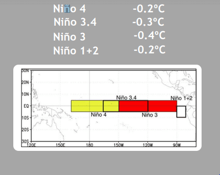
All four Niño indices across the equatorial Pacific have remained under 0°C for the third consecutive week. The Niño 3.4 region, the marker index for ONI, has a consistent anomaly of -0.4°C. While sub-surface waters in the tropical Pacific have shown clear signs of cooling in recent weeks, the atmospheric indicators still remain neutral. There is a relatively large spread in the model forecasts, indicating more uncertainty than usual in the ENSO forecasts.
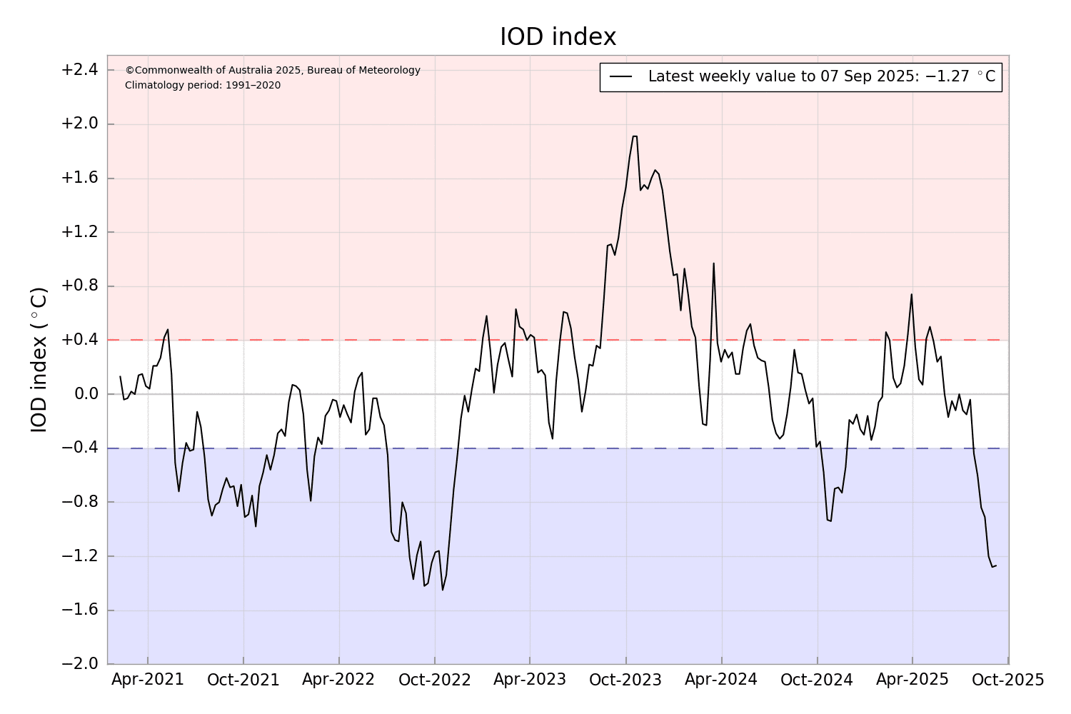
IOD: The Indian Ocean Dipole is neutral; however, the last seven weeks of the IOD index have been below the negative IOD threshold. The latest IOD index for the week ending 07 Sep 2025 was -1.27°C. Sustained index values less than or equal to -0.4°C for at least eight weeks are typical of a negative IOD event. So far this century, there have been four negative IODs: 2010, 2016, 2021, and 2022. Consecutive positive or negative IOD events are not very common, but this norm was defied in 2021-2022. Courtesy of the triple-dip La Niña (2020-22), despite the negative IOD, the Indian Summer Monsoon rainfall was normal/above normal, both in 2021 (99%) and 2022 (106%). The third decade of this century (2021-30) seems to be dominated by negative IOD events.
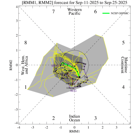
MJO: The Madden-Julian Oscillation is the major fluctuation in tropical weather on a weekly to monthly timescale. The MJO is characterized as an eastward-moving ‘pulse’ of clouds and rainfall near the equator that typically recurs every 30-60 days. The MJO is currently not well defined, meaning its characteristic eastward propagation is weak and disrupted. The enhanced part of the MJO is situated over the Western Hemisphere and the western Indian Ocean. The suppressed phase is located over the Maritime Continent. The overall strength of the MJO event is not as robust as previous events during July and August. Most models suggest that the MJO will move eastward into the circle and become weak and indiscernible over the next few days. The MJO’s impact on weather patterns is expected to be minimal in the immediate future.
None of the oceanic parameters favor a strong push for the monsoon current. Cool equatorial Pacific nearing La Niña threshold, negative IOD conditions, and incoherent MJO, working in tandem, may retard monsoon activity in its closing phase. It may hasten the withdrawal of monsoon, starting with North India, anytime soon.


