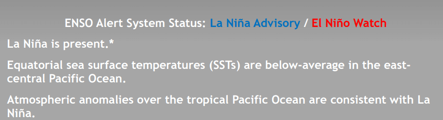
ENSO Alert System Status Changed: El Nino Caution Sounded


Key Takeaways:
- ENSO status shifts from La Niña Advisory to El Niño Watch, signaling possible development within six months
- Around 60% probability of El Niño emerging between June and August
- Positive IOD currently in place may help offset adverse monsoon impacts
- MJO activity remains weak and unlikely to influence storm systems
The Climate Prediction Center, in its recent update, has changed the ENSO Alert System Status. The earlier La Niña Advisory has now been overlapped with an El Niño Watch. It means it is a confirmation of El Niño emerging within the next about six months. It raises the risk of an evolving El Niño, starting anytime around the beginning of the monsoon season.
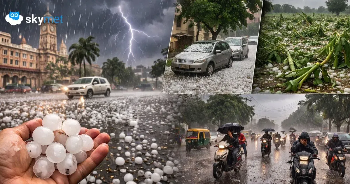
Earlier murmurs of El Niño are growing louder and, therefore, entailing anxious moments for the monsoon season. Already, there are enough indications that El Niño will develop during the early stage of the southwest monsoon and possibly strengthen as the year progresses. There are speculations of this being a ‘super’ El Niño and it may get listed among the most intense events.
Climate models suggest that the current La Niña phase in the Pacific Ocean will weaken, and the ocean-atmosphere pattern will shift towards neutral conditions shortly after the ‘spring barrier’ gets over. Forecasts from global weather agencies indicate roughly a 60% chance of El Niño emerging between June and August, with the probability rising further towards the fall of the year.
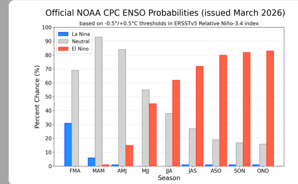
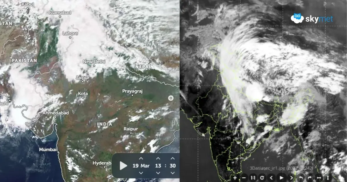
ENSO: A transition from La Niña to ENSO-neutral is expected next month. ENSO-neutral is favoured through May–July 2026. The subsequent quarter of June–August may be overlapping, sounding more emphatically the exit of ENSO-neutral and the quick arrival of El Niño. With this, it could begin affecting global weather patterns—including India’s monsoon—particularly during the second half of the rainy season.
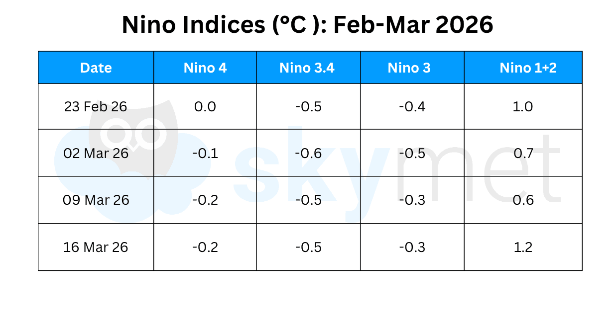
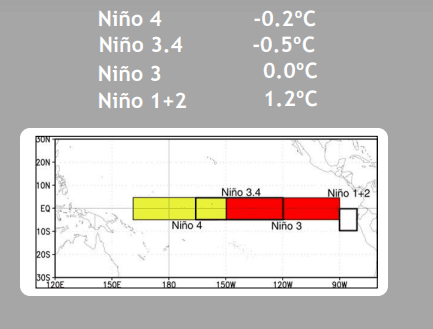
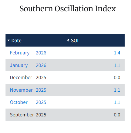
With the modified process of ONI to RONI, the Niño 3.4 index has nearly stagnated at the threshold mark of -0.5°C for the last four weeks. It means La Niña conditions are continuing. The RONI, which is based on Niño 3.4 temperature anomaly, is the principal measure for monitoring, assessing, and predicting El Niño. The atmospheric state also supports the protraction of La Niña for some more time. The Southern Oscillation Index (SOI), representative of the atmospheric arm, had a mean value of 1.4 for the month of February. For initiation of ENSO-neutral, RONI essentially needs to incline towards warmer anomalies consistently and the SOI also, in tandem, should fall off substantially. It may take another 4–5 weeks for the two indices to align with the ENSO-neutral state.
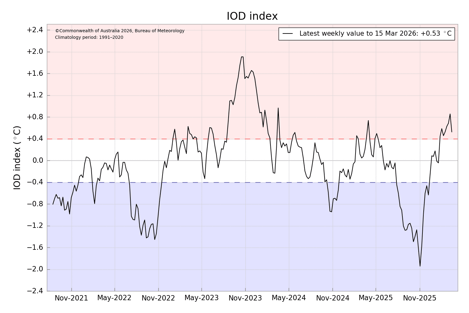
IOD: As the scare of El Niño hounds the Indian monsoon, the role of IOD becomes crucial in the coming days. However, the reliability of the IOD forecast lowers with a lead time of 7–8 weeks. Therefore, it is too early to speculate its contribution, whichever way. As of now, the positive IOD event is in place, as the index has remained above the threshold mark of +0.4°C for the last eight successive weeks. The latest value of the index for the week ending 15th March 2026 was +0.53°C, a significant drop from its earlier mark of +0.86°C on 08 March 2026. The IOD pattern needs close observation for the next about four weeks. A strong positive IOD has a historic record of saving the monsoon from the adverse effects of El Niño.
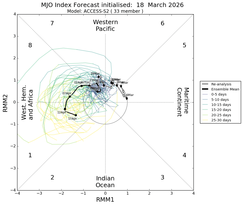
MJO: Madden–Julian Oscillation is a travelling pattern, propagating eastward at approximately 4–8 m/s through the atmosphere above the warm waters of the Indian and Pacific Oceans. The MJO is more clearly manifested as anomalous rainfall. This rainfall is usually first evident over the Western Indian Ocean and remains discernible as it propagates over the warm ocean waters of the Western and Central Tropical Pacific Ocean. The MJO pulse is likely to meander over the Western Pacific in Phase-7 till the end of March, and that too with limited amplitude. It is going to be inconsequential for any stormy activity over the Western Pacific and Indian Seas during this period.
The ‘spring unpredictability barrier’ syndrome will be getting over shortly. The ENSO pattern will get stabilised and more realistic thereafter. The degree of confidence and reliability of the monsoon forecast will increase. Like earlier years, a comprehensive monsoon forecast will come from Skymet around mid-April.