El Nino Transition From Weak To Moderate: Very Strong Likely After Monsoon

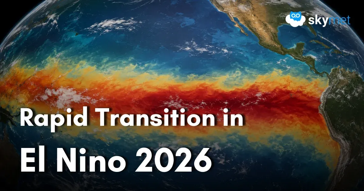
Representational Image: AI-Skymet
Key Takeaways:
- The 2026-27 El Niño is strengthening rapidly and could become one of the strongest events on record.
- Climate models project Niño 3.4 temperature anomalies exceeding 3.5°C, potentially setting a new record.
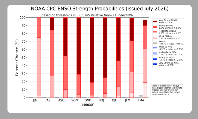
- NOAA assigns a 97% probability that El Niño will persist into early spring 2027.
- A stronger El Niño increases the likelihood of expected climate outcomes but does not guarantee severe weather impacts everywhere.
- Forecast Validity: Till the next update.
El Niño conditions are strengthening across the tropical Pacific, with sea surface temperature anomalies in the Niño 3.4 region showing a steady upward trend. The developing 2026-27 El Niño is strengthening at a much faster pace compared to previous similar events. Models are forecasting something outside the envelope of anything observed during earlier extreme El Niño events.
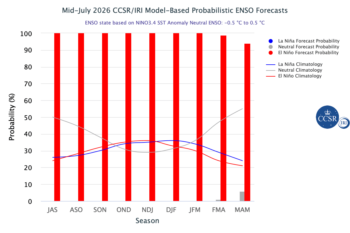
As per the ensemble forecasts from seasonal climate models, the event is expected to be far stronger than the outliers of 1997-98 and 2015-16. According to preliminary estimates, the temperature anomaly in the Niño 3.4 region of the tropical Pacific may peak above 3.5°C, surpassing the previous record of 2.75°C reached during the powerful 2015-16 El Niño.
However, even the strongest events do not necessarily correlate with extraordinary impacts in terms of disrupting weather patterns over different parts of the globe. Such high-magnitude events ensure that the episode is likely to progress without interruption, with the least possibility of collapsing midway, as happened in a few cases in the past.
There is an extremely high probability of a very strong El Niño that could rank among the largest in historical records dating back to 1950. But, even at the cost of repetition, it must be emphasized that the strongest El Niño events do not always produce typical impacts everywhere. Stronger events can, however, tilt the odds more significantly in favour of expected outcomes.
The United States Climate Prediction Center (CPC) under the National Oceanic and Atmospheric Administration (NOAA), in its latest report, expects El Niño to strengthen through the end of the year and assigns a 97% probability that it will persist into early spring 2027.
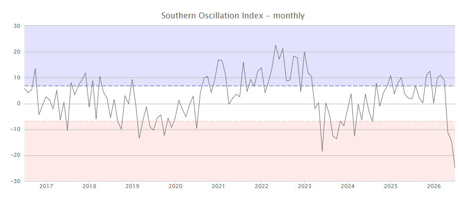
ENSO: Sea surface temperatures (SSTs) in the central tropical Pacific are above the El Niño threshold, and atmospheric indicators are consistent with an El Niño state. Atmospheric indicators such as trade winds, pressure patterns, and cloud distribution are firmly compatible with El Niño conditions. Trade winds are either reversed or weaker than average across the western tropical Pacific. The Southern Oscillation Index is strongly negative and remains in agreement with the oceanic component of ENSO.
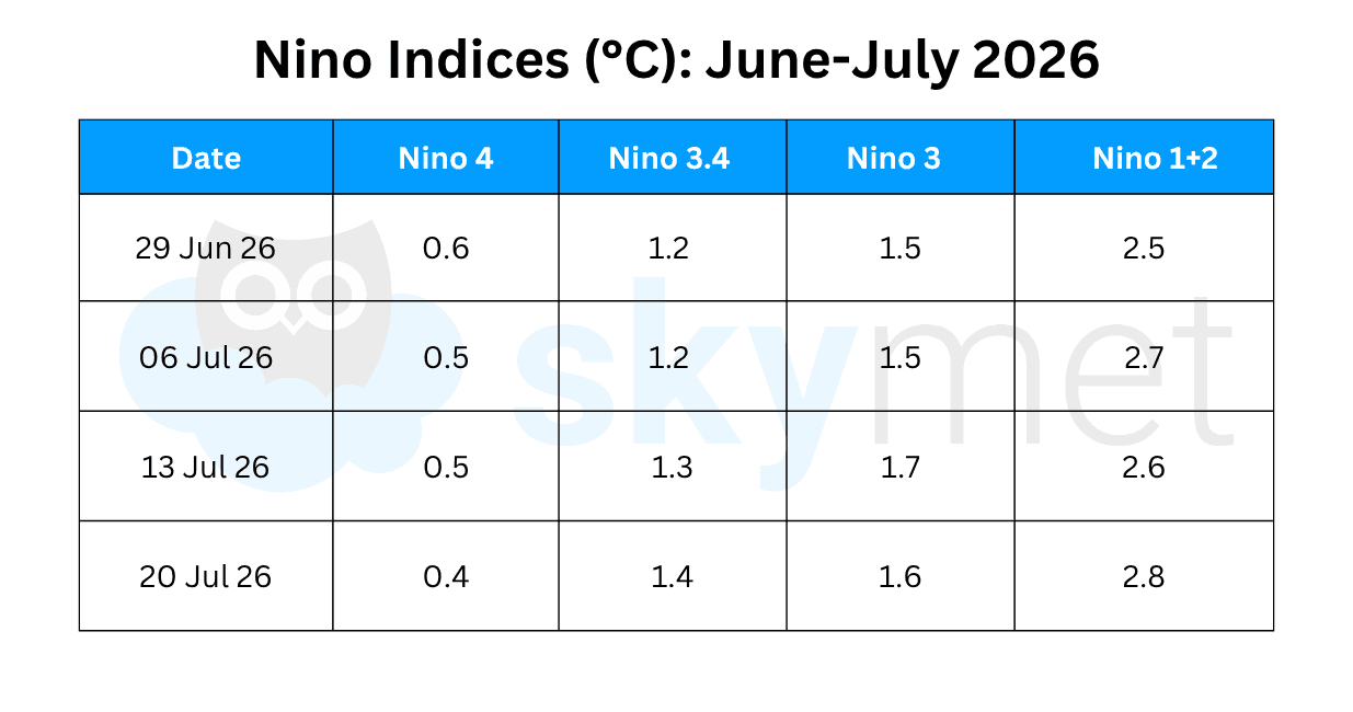
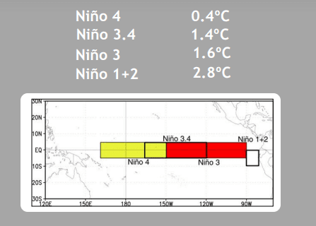
There are only incremental changes in the Niño indices across the central and eastern tropical Pacific Ocean. The temperature anomaly has marginally decreased in the Niño 4 and Niño 3 regions while increasing by a similar margin over Niño 3.4 and Niño 1+2.
The Bureau of Meteorology (BoM) follows different standards than NOAA for assessing El Niño conditions. According to BoM, the latest relative Niño 3.4 index value was 1.47°C, well above the threshold of +0.8°C. According to NOAA, the Niño 3.4 index value for the week ending July 20, 2026, was 1.4°C, again well above the threshold of +0.5°C. All models forecast the tropical Pacific to continue warming, allowing El Niño conditions to rapidly transition from the weak to the moderate category.
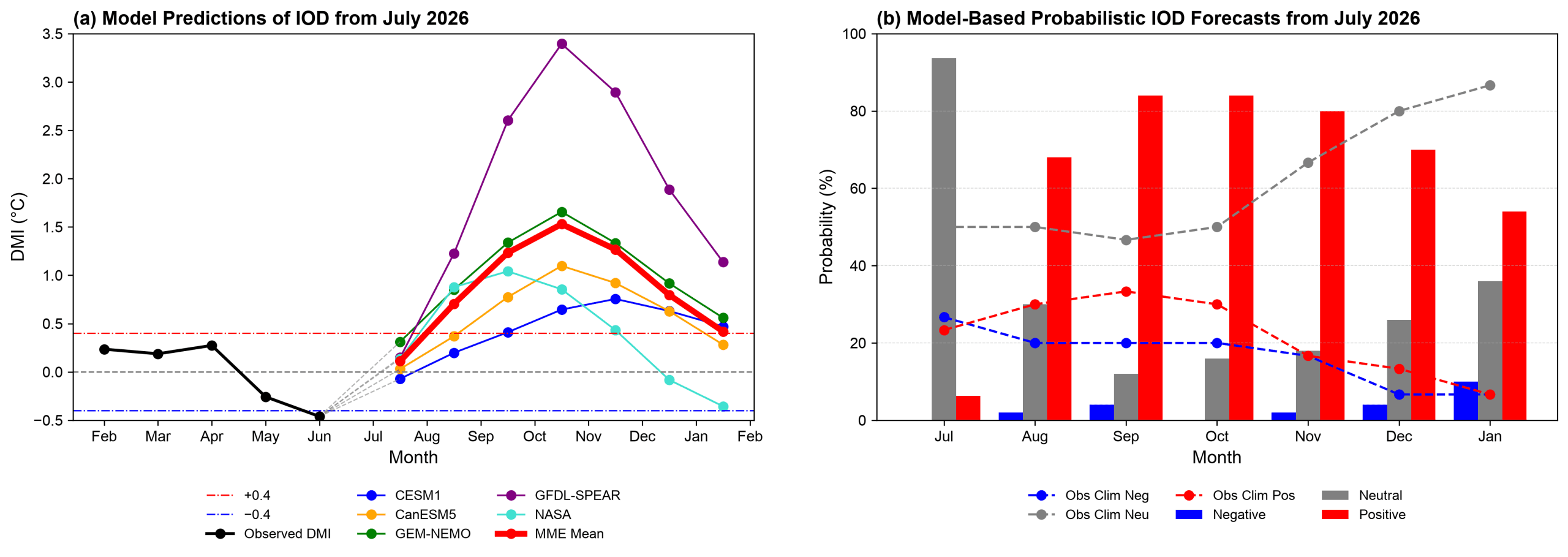
IOD: Sea surface temperature variation in the Indian Ocean is becoming increasingly important in assessing climate variability. The lead time for skillful prediction of SSTs in the western Indian Ocean is about five to six months, while for the eastern Indian Ocean it is only three to four months. Reliable prediction of the Indian Ocean Dipole (IOD) is generally limited to about one season.
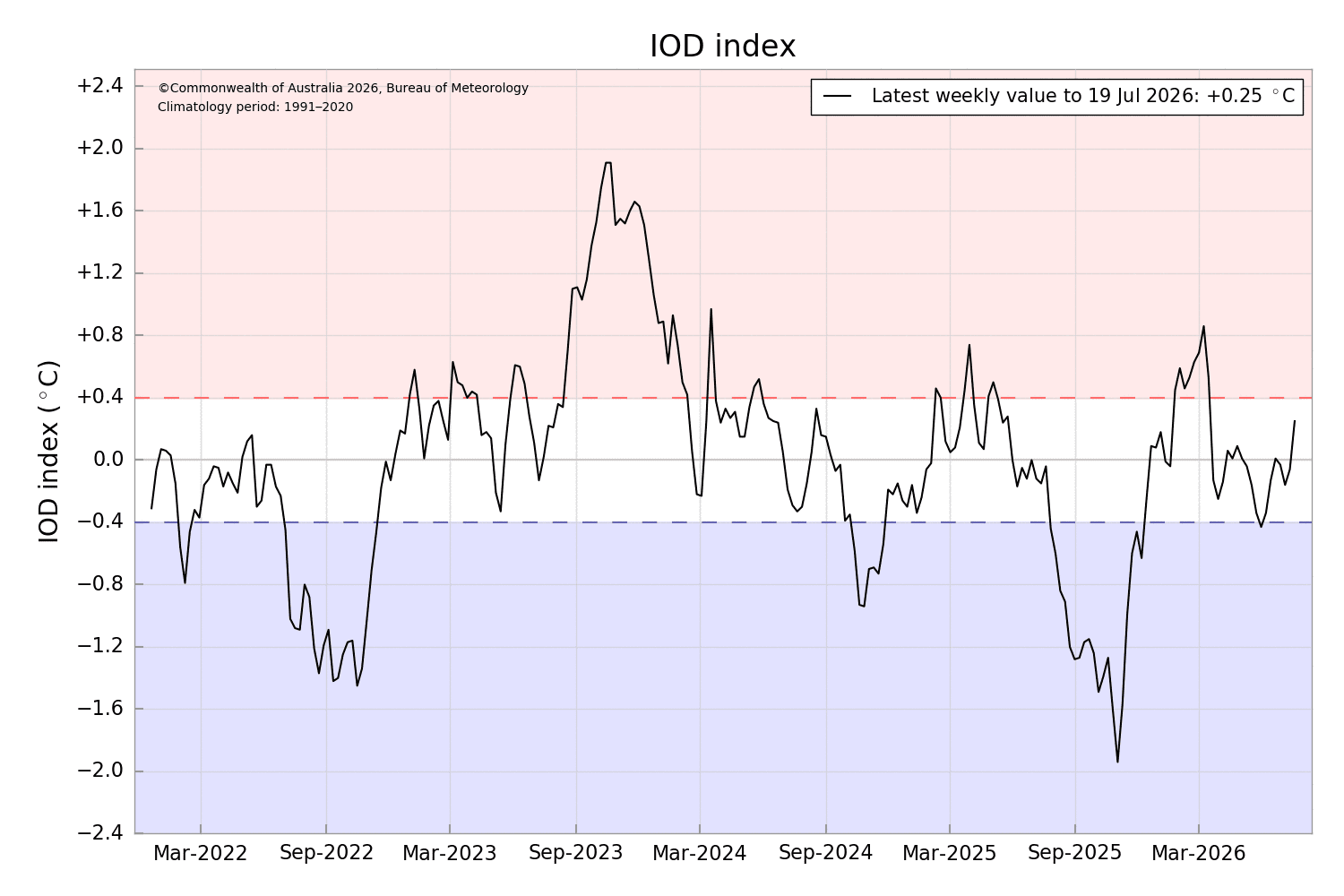
The IOD is currently neutral, and the latest index value for the week ending July 19, 2026, was +0.25°C. The index had hovered close to neutral for many weeks, and this is the highest positive value recorded since March 15, 2026.
Climate models are predicting the development of a positive IOD event, although there is considerable variation regarding its timing and intensity. Neutral IOD conditions also remain a possible outcome.
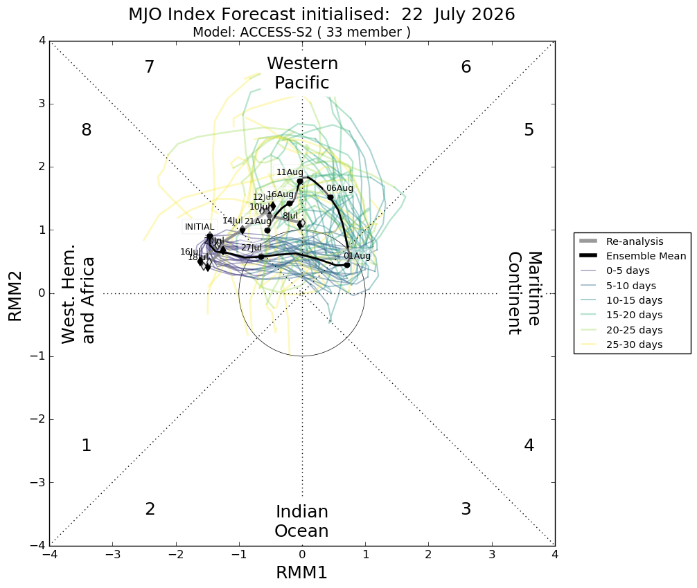
MJO: The Madden-Julian Oscillation (MJO) pulse has been travelling around the globe with a periodicity of about 30 to 40 days. It has remained mostly dormant due to destructive interference from the El Niño background state.
The MJO is expected to propagate eastward and move into close proximity to the Indian Ocean. However, the index is likely to weaken, and the amplitude of the MJO signal may become too small to significantly influence weather patterns over the Indian seas.
A very strong El Niño during the monsoon and autumn seasons of the Northern Hemisphere does not necessarily imply severe disruption of weather patterns across the Asian region. ENSO is only one of many factors influencing climate over and around the Indian subcontinent.
The strength of El Niño is not strongly correlated with the severity of its consequences. Even weak to moderate El Niño events in the past have adversely affected the Indian monsoon, as witnessed in 2009, a severe drought year when seasonal rainfall was only 78% of the Long Period Average (LPA).