Impact Of El Nino-Global Weather Pattern

Representational Image: AI-Skymet
Key takeaways:
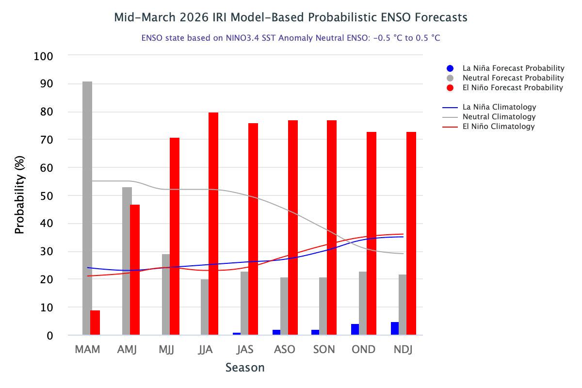
- ENSO is shifting from La Niña toward neutral, with El Niño probability rising sharply to 47% in Apr–Jun
- El Niño likely to dominate from mid-2026 onward, influencing global weather patterns
- Indian monsoon faces risk of suppression, delayed onset, and below-normal rainfall
- Pre-monsoon activity may stay active till mid-April, limiting early heatwave conditions
As of March 2026, the equatorial Pacific is transiting from declining La Nina conditions toward ENSO-neutral. It remains the dominant category during Apr-Jun (53%), but the El Nino probability also sharply rises from 9% of previous quarter to 47% in Apr-Jun. Thereafter, El Nino becomes the commanding category and remains so, till fall of the year.
El Nino is a climate pattern characterized by the warming of Pacific Ocean surface waters and weakened trade winds, driving major global weather shifts. It typically triggers drought in Southeast Asia, Australia, and parts of Africa, while causing heavy rainfall and flooding over East Africa and coastal South America.
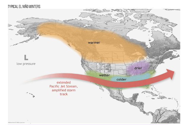
U.S: Historically, strong El Nino conditions reduce tropical storm activity in the Atlantic, especially in the Western Atlantic Ocean Basin. Warm waters in the Pacific form an El Nino, which causes increase in the wind shear. This triggers change in the wind speed and direction in the tropical Atlantic Basin. It also leads to inconsistency and imbalance in the atmosphere, which is considered detrimental for growth and sustenance of storms. Resultantly, the El Nino can actually decrease the intensity and frequency of hurricanes in the Atlantic Ocean. East Coast of U.S is presumed slightly safer for stormy activity during El Nino. Notwithstanding, the storms at times defy the logic and behave differently. Afterall, as an exception, the El Nino year of 2023 found Atlantic hurricane season as one of the most active with 20 named storms. El Nino usually (not always) coincides with cooler, wetter conditions for the Southern U.S, while the Northern U.S and Canada experience warmer-than-average temperatures. Drier conditions are seen in the Ohio Valley and Pacific Northwest regions.
Pacific Ocean Ring Countries: During El Nino events, the increased sea surface temperatures disrupt typical atmospheric circulation pattern. El Nino influenced weather systems bring more intense cyclones in the Northwest Pacific, and more frequent cyclones in the South Pacific. During El Nino, typhoon activity in the West Pacific often shifts eastward, with storms forming further Southeast, little away from South China Sea and closer to Central Pacific allowing more time to intensify. These storms tend to be more powerful due to increased heat potential. While, the total number of storms may be near average or slightly less, their increased intensity and longer tracks often leads to greater and frequent impact across the region.
Philippines/Japan: Storm are more likely to recurve northeastward, affecting areas like Japan and the Philippines rather than making landfall on the Asian mainland. Despite higher intensity, the fewer typhoons may directly hit Chinese mainland during El Nino years.
Southeast Asia/Indonesia: While the region experiences drought during El Nino, the few typhoons do pass nearby and cause severe weather. Majority of these storms skip the region.
Africa: El Nino causes extreme weather across Africa, typically driving severe droughts in Southern Africa and triggering floods in East Africa. The 2023-24 event brought drought over Southern Africa affecting over 60 million people and floods in East Africa displacing 5 million people and severely damaging agriculture. El Nino often results in below-average rainfall, leading to severe droughts in countries like Angola, Malawi, Mozambique, Zimbabwe, Botswana, Lesotho, Namibia, South Africa, Zambia and Eswatini. Conversely, East Africa, next to the Arabian Sea often experiences heavy rains and flash floods.
Australia: El Nino typically brings hotter, drier conditions to eastern and northern Australia. Significant rainfall deficit leads to droughts and intense heat wave conditions. The onset of wet season in Northern Australia is often delayed. The number of tropical cyclones also decrease substantially.
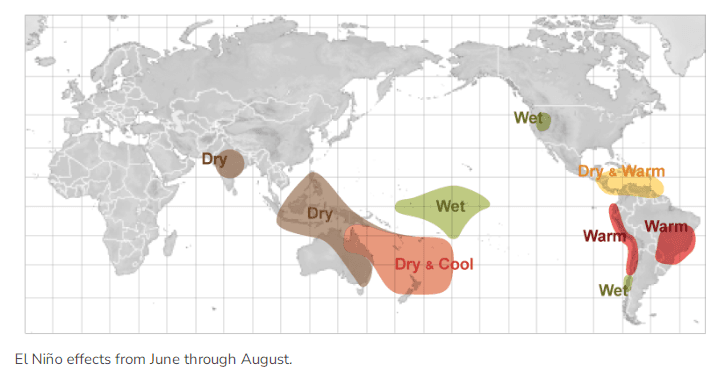
Indian Sub-Continent: El Nino typically suppresses the Indian Monsoon by warming the central/eastern Pacific, causing deficit rainfall, weak monsoon winds, and higher drought risk. Historically, 70% El Nino years bear the risk of drought/below normal rainfall. El Nino can even cause a delay in the arrival of monsoon. It also leads to frequent, intense and prolonged heat wave conditions.
ENSO: The World Meteorological Organization says that our planet is gaining much more heat energy than it can release, driven by emission of warming gases such as carbon dioxide. This record “energy imbalance” heated the ocean to new heights last year and continued to melt our planet’s ice caps. Another natural warming phase on account of El Nino is expected to begin in couple of months which could further add to the heat records. The last 11 years were the Earth’s warmest years on record. 2024 remains the hottest year and 2025 was the second or third warmest year. Courtesy, year and a half long La Nina conditions, temporary cooling of Pacific Ocean dragged the year 2025, second/third to 2024. The likely El Nino 2026 may add to the ocean warming more effectively in early 2027, as the peak warming may happen at the end of the year. The manifestation of ocean warming as such, has a lag of about three months.
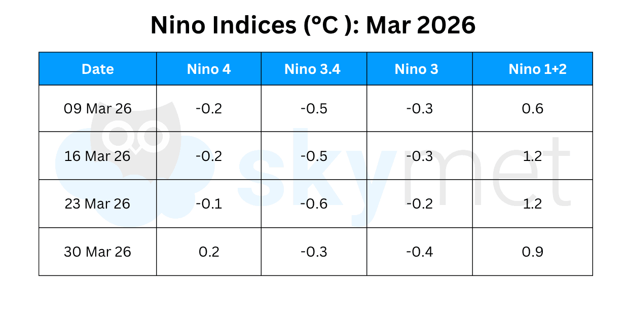
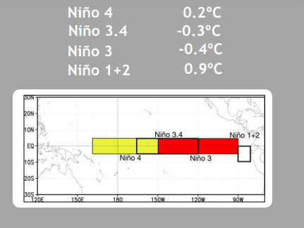
Since early Jan 2026, below-average SST’s have gradually weakened across most of the equatorial Pacific. Beginning in early Feb, the above average SST’s emerged in the far eastern equatorial Pacific. The eastern half of the Nino region has warmed up slightly during the last week. But, the warming is not uniform. Nino 3.4 region temperature anomaly has recorded eight week high of -0.3°C on 30th Mar 2026. The average Nino 3.4 index for the month of March stands at -0.5°C. The Oceanic Nino index for the quarter Jan-Feb-Mar is likely to be around -0.6°C. The quarterly index essentially need to vacate the threshold mark of -0.5°C and locate within +/- 0.4°C for ENSO-neutral phase to start.
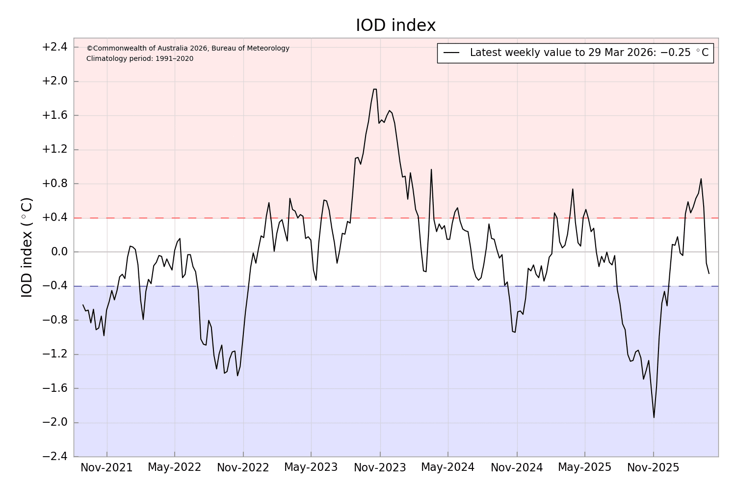
IOD: Going by the historic records, the IOD remains neutral or positive during El Nino years. As such, the IOD cycle is more pronounced between May and November. After the reversal of trend, the Indian Ocean Dipole continue to remain neutral, but marginally negative. The latest value of the index for the week ending 29thMarch 2026 was -0.25°C. It is likely to stay within the threshold mark of +/- 0.4°C in the month of April 2026.
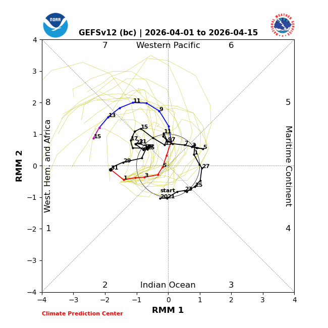
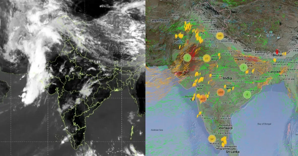
MJO: The Madden Julian Oscillation has propagated eastward across Western Hemisphere. The magnitude of the pulse has decreased and is confined to the inner circle. All the three oceanic parameters: ENSO, IOD and MJO have marginal influence on the weather conditions without any significant interaction with other equatorial waves. MJO is unlikely to support any storms in the Indian Seas, at least till mid-April.
ENSO and IOD will continue to be in the transition phase during the month of April 2026. An uptick in the pre-monsoon activity is anticipated over the Indian sub-continent till mid-April. Consequently, typical April heat conditions are unlikely in the first half of month.