Oceanic Nino Index Grows Stronger: Only Strong IOD Can Bail Out Monsoon


Key Takeaways:
- ENSO-Neutral conditions are rapidly shifting towards a likely El Nino event during June-July 2026.
- Sea surface temperatures remain near record highs, increasing concerns about a possible Super El Nino later this year.
- Positive IOD conditions may reduce the adverse impact of El Nino on the Indian monsoon.
- MJO activity and Bay of Bengal cyclogenesis could support early monsoon advancement over mainland India.
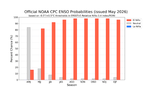
As of early May 2026, the equatorial Pacific Ocean is in a transition phase, with “ENSO-Neutral” conditions presently prevailing but rapidly shifting towards a likely El Nino event starting between June and July 2026. Models indicate a high confidence (over 60% chance) that El Nino will emerge during this period, with potential for development into a strong event by late 2026. Sea surface temperatures are already close to all-time highs, including closer to the 2024 record. April 2026 sea surface temperatures were the second-highest ever measured.
April was the third-hottest month globally on record, sitting 1.43°C above the pre-industrial benchmark. Potentially, the very strong El Nino event, more commonly being called as ‘Super El Nino’ is the result of the total disruption of the trade easterly winds in the tropics and over the equatorial Pacific region. These winds weaken, heat builds up across the Pacific, and the weather system pattern turns chaotic, with some regions getting deluged and others dry out. Only four Super El Nino events have been recorded in modern history: 1982-83, 1991-92, 1997-98 and 2015-16. The highest temperature anomaly had reached +2.5°C in 1982-83. Each one triggered droughts, floods, wildfires, and endangered food security across multiple continents. The numerical model forecasts the coming event to be even stronger-possibly rivalling a “Super El Nino” four decades ago.
ENSO: Ocean temperatures are edging towards record highs as conditions shift towards potentially powerful El Nino weather pattern. Accordingly, 2027 may exceed 2024 for the warmest year on record, as the impact on global temperatures typically comes the year after its peak. Regardless of the strength of El Nino, its mere presence knocks-off ecological balance, jeopardizing environmental resilience and health of planet Earth. Scientists stress that El Nino alone is not driving the extraordinary ocean warmth or its knock-on effects such as coral bleaching and marine heat waves. The phenomenon is unfolding against a backdrop of long-term global warming caused primarily by greenhouse gas emissions, with oceans absorbing around 90% of the excess heat generated by human activity.
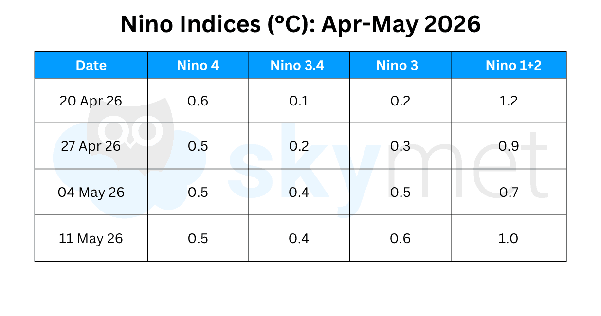
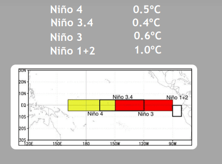
Since mid-April 2026, near-to-above average SSTs persisted across most of the equatorial Pacific Ocean. Since 20 April 2026, all the four indices in the Nino region have remained above 0°C. However, the marker index Nino 3.4 has been the least warm in the last weekly observation. The temperature anomaly in the Nino 3.4 region continue to be +0.4°C for the second consecutive week. It is expected to rise sharply.
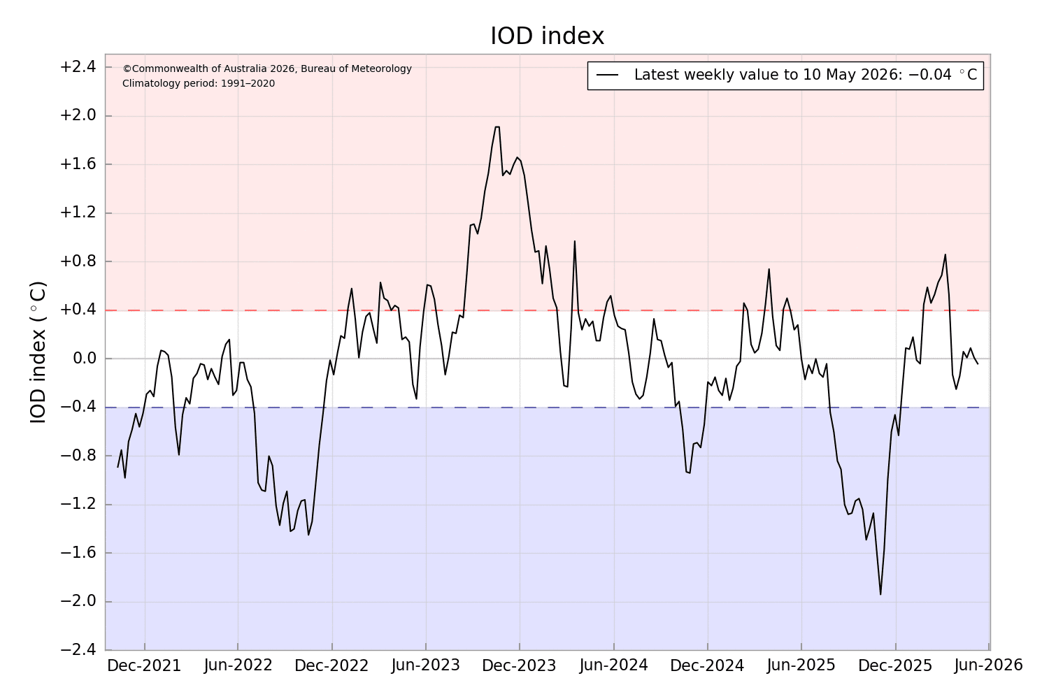
IOD: The IOD and El Nino are linked ocean-atmosphere phenomenon, that significantly impact global weather, particularly the Indian monsoon. El Nino often triggers a positive IOD which can counteract El Nino’s typically drying effect on India by promoting warmer waters in the western Indian Ocean. This configuration has the potential to bring decent rains, despite fears of drought on account of El Nino. Positive IOD has saved the Indian monsoon from the ‘blues’ of El Nino on more than one occasion.
The Indian Ocean Dipole has remained nearly zero-zero for the last five weeks, since 12Apr2026. It is a typical IOD pattern before the arrival of El Nino. The IOD index for the week ending 10May 2026 was -0.04°C. The IOD is likely to become positive during June 2026 and cross the threshold mark of +0.4°C, sometime late in July or August 2026.
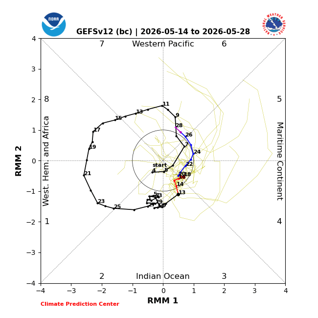
MJO: The Madden Julian Oscillation is an intra-seasonal oceanic index having two phases. Active phase (enhanced rainfall) and suppressed phase (least rainfall). For convenience, the meteorologists have divided the planet into eight phases (Phase 1-8). At any point of time, two of these are active, another two are mild and the rest four may be sleepy. The amplitude of MJO is another factor of concern and rather tricky to predict. For the Indian monsoon, MJO in Phase 2 & 3, with an amplitude of 1 and above is considered favourable for enhancing rains, lasting for 7-10 days.
The MJO was more disorganized during the first two weeks of May 2026, as other modes of variability interfered with eastward progress of enhanced convection over the Indian Ocean. MJO signal was nearly stalled and the forecasts depict eastward progression, albeit with a fairly weak amplitude as the pulse crosses the Maritime Continent. Many GEFS and ECMWF ensemble members show a re-amplification as it crosses the Pacific during late May or early June.
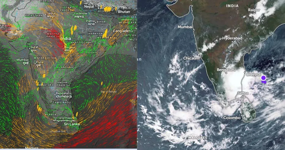
The forecast MJO evolution supports enhanced chances for tropical cyclogenesis over the Indian Ocean basin, with dynamical models favouring the Bay of Bengal. After the early onset of monsoon over the Andaman Sea, MJO signal will favour before time advance of monsoon over the mainland, as well.