Nino Indices Stride For La Nina: IOD Slumps Near Normal
Key Takeaways
- ENSO affects Earth’s energy budget, but its temperature swings are driven by ocean dynamics rather than changes in planetary heat absorption.
- The Nino 3.4 region shows strong cooling, signalling the likely onset of La Niña by late December.
- The IOD is rapidly weakening from a strong negative phase toward neutral conditions.
- An active MJO and emerging La Niña may influence tropical weather, including heavy rain over South Peninsular India due to Cyclone Ditwah.
Earth’s average global surface temperature is determined by the balance between incoming sunlight and outgoing heat energy. However, the warming of the Pacific during El Niño and the cooling during La Niña are not part of this energy balance. During El Niño years, the warmer ocean in the tropical Pacific heats the atmosphere above, mainly through evaporation, which leads to cloud formation.
The condensation of moisture in these clouds releases latent heat, further warming the atmosphere. Additionally, the increased cloud cover over the central tropical Pacific during El Niño blocks incoming sunlight and reduces surface heating. Therefore, ENSO drives changes in Earth’s energy budget, but the reverse is not true.
The surface cooling of the equatorial Pacific during La Niña cannot be attributed to reduced energy absorption by the planet. Instead, it results from enhanced upwelling of cold water from the thermocline. The same logic applies to El Niño. On seasonal to year-to-year timescales characteristic of ENSO variations, it is the upper few hundred meters of the ocean that are most crucial for storing, transporting, and exchanging heat with the atmosphere. In contrast, human-induced global warming results from excess heat trapped in the climate system by increased greenhouse gases, which are uniformly distributed and cause surface temperatures to rise everywhere.
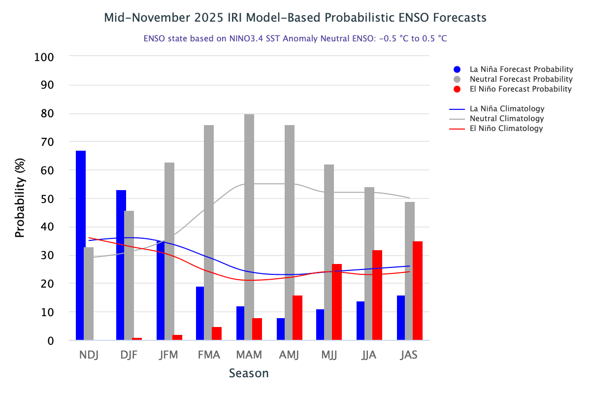
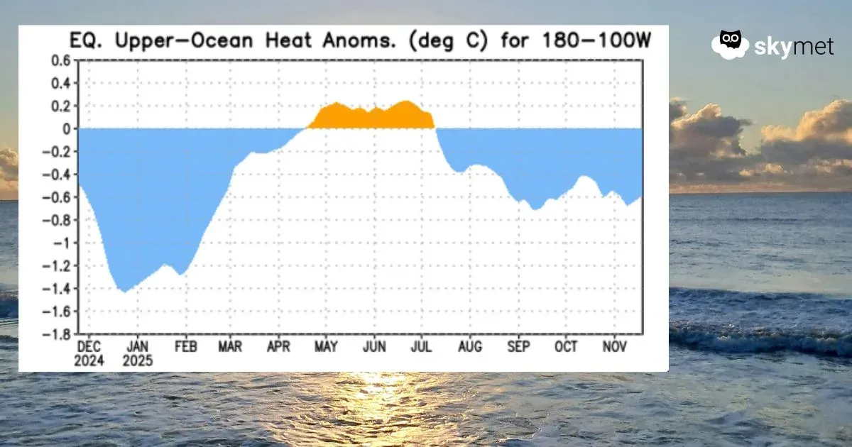
ENSO: Negative surface temperature anomalies precede negative sub-surface anomalies during La Niña. Sub-surface negative anomalies dominated from the start of the period through early April 2024. They reached their lowest point in December 2024, marking the peak of the previous La Niña event. In February–March 2025, these anomalies weakened significantly and turned marginally positive from mid-April to early July, consistent with ENSO-neutral conditions during the 2025 monsoon. Negative anomalies re-emerged in mid-July 2025 and continue at present. Persistent anomalies below the –0.5°C threshold, even at sub-surface levels, signal the likelihood of La Niña developing soon.
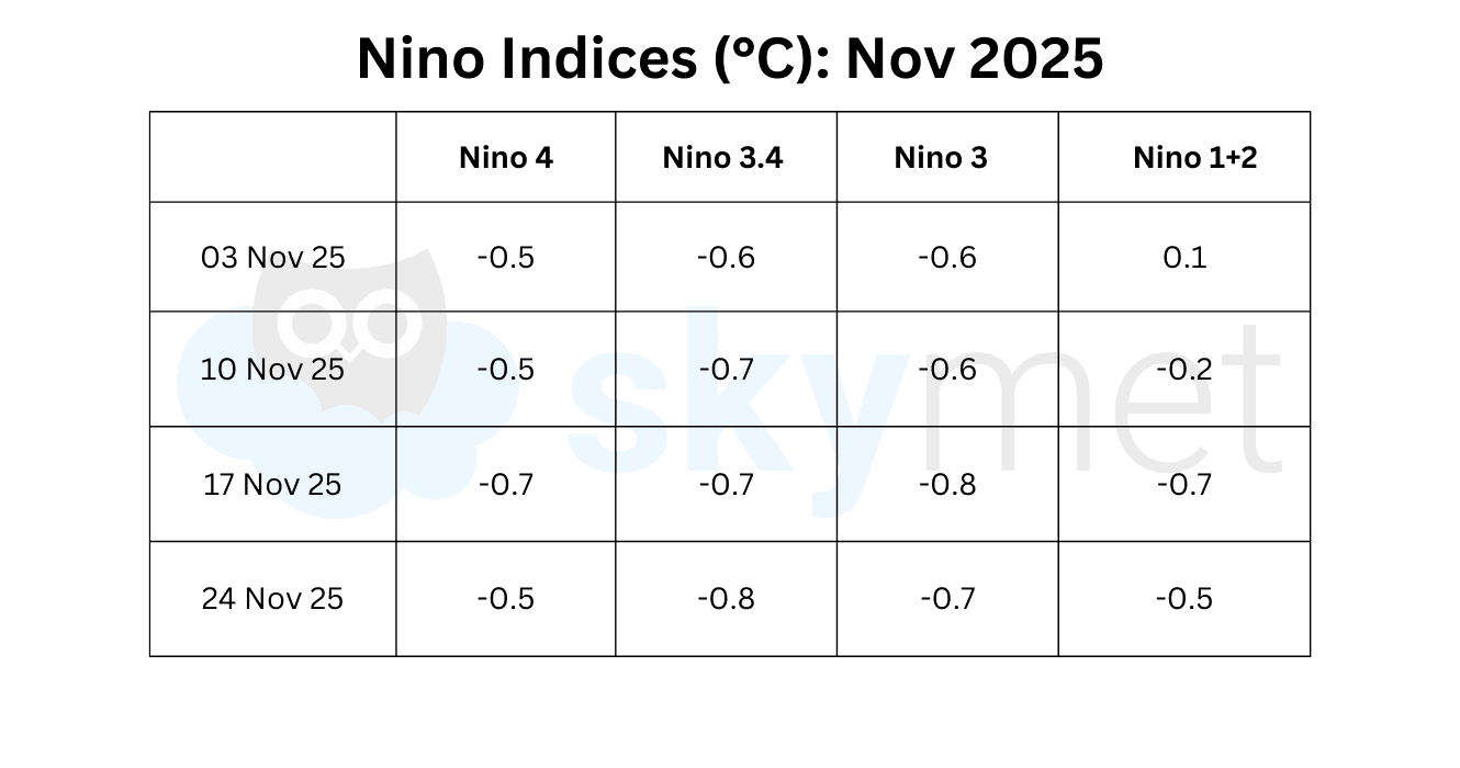
The Nino 3.4 region has turned the coldest in recent weeks. The temperature anomaly has dipped to –0.8°C, nearly matching the lowest value of the 2024 La Niña. The average Nino 3.4 index for November 2025 stands at –0.7°C, the lowest among all Nino regions. The ONI for the second consecutive quarter (Sep–Nov) is likely to fall below –0.5°C. A similar trend through December 2025 will formally confirm the onset of La Niña.
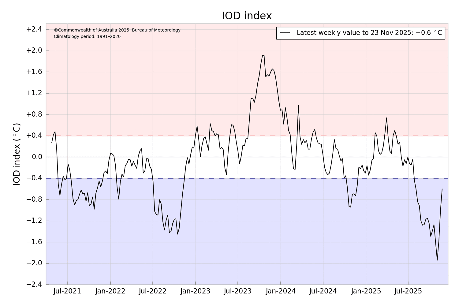
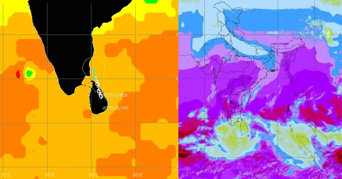
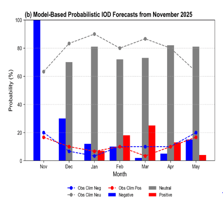
IOD: For November, model forecasts indicate strong consensus on the persistence of a negative IOD event. However, confidence declines rapidly in December 2025, with the probability of a negative phase dropping below 40% and neutral conditions rising correspondingly. The latest IOD index for the week ending 23 November 2025 was –0.6°C, a sharp reduction from –1.94°C three weeks earlier. From December 2025 to May 2026, forecasts favour a shift toward IOD-neutral conditions, indicating rapid weakening. The chances of a positive IOD remain very low throughout the forecast period.
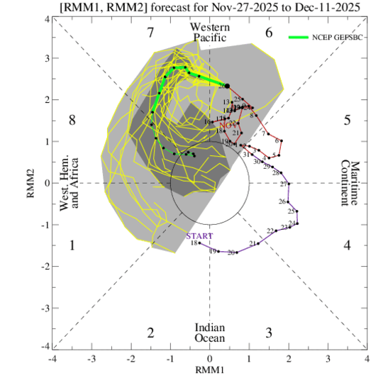
MJO: Global tropical circulation suggests that the Madden–Julian Oscillation will remain active, with its enhanced convective phase positioned over the Western Pacific. Emerging La Niña conditions may dampen its amplitude by mid-December, but the MJO is still expected to play a significant role in shaping tropical weather patterns during the first half of December.
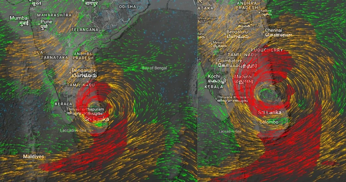
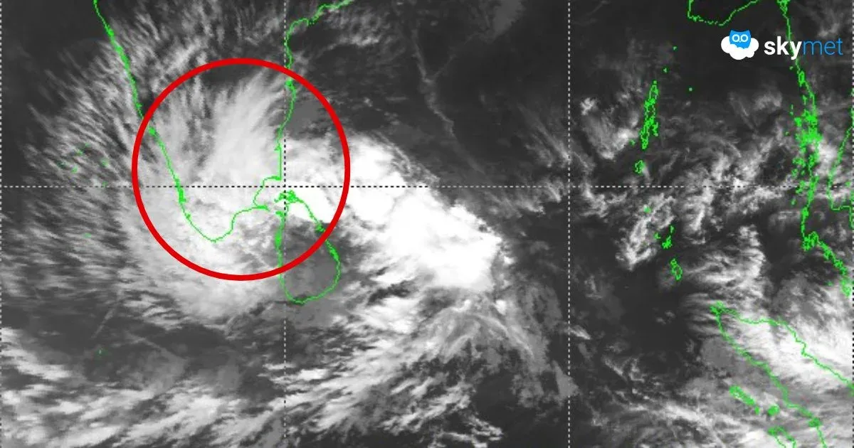
The MJO will keep the equatorial region active on both sides of the Indian seas. Tropical Storm Senyar weakened rapidly due to insufficient Coriolis force at low latitudes, resulting in a very short lifespan as a named storm. Another system, Cyclone Ditwah, is now entering the Southwest Bay of Bengal on a subdued note but is still likely to produce heavy rainfall across most parts of South Peninsular India this weekend.


